
21 Jun 2026 – Special Father’s Day Post


Happy Father’s Day to all fathers with special memories of my own father LAM TinYue(1911-1996) who was pro-British all his life.
Note: longest blog posting ~5,000+words! with ~15 previous blog postings from Jul-Aug2013 combined here and a special dedication with appreciations&tkx to GlendaTriplett who made this hike possible.


Acknowledgements
Tkx to KK/SIN for the above FT/Weekend pp6 10-11Jan2026 – a reminder of this 2013-hike and pleased to read about the improved&extra waymarkers upgrade works considering the many extra km/miles walked bc of the lack of signages! Dedication to GlendaTriplett,NC/USA for whom this hike would not have happened. Appreciations to Christine&KV/UK who got me to the trains; special thanks to cousin YatSoon&family/UK for taking care of me along the way and to all who crossed my path there. Grateful for Jul/Aug2013 blog postings making this posting possible.

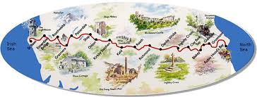
Just because the 2,175mi 3500km (127days) AT-thru’-hike/USA and McLehose/HKG 63mi 100km (7days) were completed, does not mean that the 192mi 310km UKc2c/UK (16days) thru’-hike was a piece of cake! Every long distance (anything 20+km per day over a couple of days) hike is different and just as difficult but if one really determine and discipline to complete it, then it can be done. Most important, that you enjoy walking in peace with nature.
Used to comment that it is so quiet that you can hear yourself think. One of the recent hikers commented that it is so quiet that you can hear the silence. That is exactly how it is and if you cannot handle this, long distance hiking is not for you.
References
Fri26Jul2013 – StonehouseFarm/StBees


27 – 31 July 2013 – Lake District-Cumbria
Sat27Jul2013: Day1 StBees – EnnerdaleBridge 14mi/22.6km 0730-1630hrs including breaks


Night: Sat 27 Jul@Cloggers/Ennerdale Bridge, Cumbria GBP35 S$68. Thank you David for the load of an excellent map and for his advise.
Sun28Jul2013: Day2 EnneradaleBridge – HonisterPass 11mi/17.7km 0700-1500hrs


Night: Sun28Jul@HonisterHauseYHA/Seatoller,Keswick,Cumbria GBP18 S$35
Mon29Jul2013: Day3 HonisterPass – Grasmere 12mi/19.3km 0700 – 0430


Night: Mon29Jul@BroadrayneFarm/Grasmere,Keswick,Cumbri GBP21 S$40
Tue30Jul2013: Day4 Grasmere – Patterdale 9m/14.5k 0830-1400hrs
Treat to have the extra time for this shorter mileage day. Got up at 0600hrs as usual to hear the rain, dozed for another hour or so and the rains stopped by the time the feet hit the trail.


Leaving Grasmere with the view of HelmCrag in the background and slowly ascending a rocky path with the new path under construction parallel to this path across the stream.


Long climb uphill but was worth all the effort with weather and views like today. Whoever built the stone way further up is an angel. Unlike the rugged ones just on, these are quite a luxury. Turning back to say goodbye to the delightful village of Grasmere.


Took me 2hrs (others will do in 1hr!) to get up to GrisedaleTarn and it was nice to see a lone camper by the tarn. Must have been peaceful in spite of the rains during the night.


Heading downwards towards GrisedaleValley to be pleasantly surprised by this RuthwaiteLodge.


These stone fences and houses never fail to impress me. And more so now as some of the fences go all the up to where it would take me 2hrs to get to the end of the fence! How on earth did they manage to carry those stone all the way up to these mountains.


Into Patterdale village passing by StPatrick’sChurch where there will be an organ recital tonight. Will try to stay up to attend.


The centre of the village. Staying in a real working farm app a quarter-mile from the main drag, hopefully not too much baa from the sheep tonight. Pass by this sign post to the farm. Am told that the Red squirrels are a native here!
Night: Tue30Jul@NoranBankFarm/Patterdale for B&B +a packed lunch GBP35 S$68
Do not know if there will be time, energy or fast internet access to blog with so many words again! Have been told that tomorrow will be the roughest day of the whole hike… !!!
Wed31Jul2013: Day5 Patterdale – Shap 15.5m/25km 0630-1730hrs


The day start beautifully crossing the bridge looking back into Patterdale, passing by lovely cottages and up up up for nearly 2hrs.


to AngleTarn where breakfast was served from the day-pack in the company of flock of ducks and a few campers.


Still continuing upwards not realising that it was NOT the correct path, met just one lone hiker going the opposite direction but did not think to ask him being too stupid…


Was instead admiring the views which are not on the correct path!


Thank goodness for Peter and his group, took a different path but at least headed to the correct direction. Appreciations to Norman Crump of LancasterU and son for getting me into Shap which has an interesting history. Just too tired and frustrated to write…
Night: Wed 31Jul@NewIngLodge/Shap GBP22 for bed (dom-style room with 5 others) and full breakfast) S$43
1 – 5 August 2013 – Cumbria Lake District And Yorkshire Dales
Thu1Aug2013: Day6 Shap – Orton 9mi/12.6km 0830-1300hrs


Walking thru’ Shap, a village at the heart of Britain was quite a historic experience. Had to walked down the main street to get on the trail. No pix of ShapAbbey due to time and stress when passing by it yesterday. New IngLodge has a wall map of the UKc2c in the dinning room. Had fish & chips dinner last night at the ShapChippy.


Found the path leading onto the muddy and shitty! farmlands to cross the motorway on the overhead bridge. This is the first time to cross the M6, strange to see the motorway and cars zooming by.


Crossing the moors all morning, muddy and boggy but at least not misty. Glad to meet the 2familiar hikers who were at the same lodgings the night before, also doing the UKc2c. This will probably be the last I see of them as they plan to hike the whole trail in 10days. One of them has done it some years ago, so the path today must be the correct one!!


Amazing limestone pavement, quite contrasting views compared to yesterday.


Got into Orton earlier than expected to find the B&B locked! Had something to drink at the new cafe across the road and walked around the area within 15mins. Delightful village with a church getting ready for a wedding.


A chocolate factory where one can just about to get everything in chocolate.! Went back to the B&B and dozed on the steps of the entrance! Thought I was dreaming when some familiar hikers from across the road came by, and yes it was the group from StBees who I though would have been way ahead by now, but the group seemed smaller. Accompanied them to the cafe for tea to discover that 2 of their younger boys did not feel up to the hike. Fun exchanging notes, info and contacts: Daft – WellyWalkers with Jeff&Joby (father&son), George&Mark with the long hair. Thank you for crossing paths.


Cousin Yat-Soon & family are in the area and appreciations to them for driving over to pick me up for dinner in Greystoke (Tarzan), not on the walking UKc2c but on the cycling UKc2c trail. Took us 20mins to drive by Shap (took me 5hrs to walk!!!) on the way to Greystoke. Helen’s cousin owns Boot&ShoePub and thank you to Yat-Soon&Helen for a lovely dinner+pack-lunch from there. Got back to the B&B by 22.30hrs, just enough energy to brush teeth.
Night: Thu1Aug@MostynHouse/Orton GBP40 S$78 for a room and separate bathroom.
Fri2Aug 2013: Day7 Orton – KirkbyStephen 12.8mi/20.6km 0630-1700hrs


Nice weather for walking, not too hot nor wet. Long day taking many small breaks with not much spectacular, but then not towards the end of the LakeDistrict. Again over stiles and headed over fields to RavenstonedaleMoor, passing by SeveralsPrehistoricVillage/Smardale archaeological site to SmardaleBridge&SmardaleFell.


Unbelievable, there is a Chinese take-out-Panda and a chinese restaurant-Century here in KirkbyStephen with a pop ~2,000! So far the biggest place to visit. My accommodations for tonight is quite lovely.


A lovely church by the market square and all kinds of shops on the main street. Also a HSBC Bank but I do not bank with them. Finally managed to find a decent C2C map for S$16 at the visitor centre just across the street from where I am staying. Somehow all the village churches have been interesting and after being thru’ these villages, one can understand that living in such remote areas in the days where transport&communication were not so accessible, faith in such communities is an important way of life.
Night: Fri 2Aug@OldCroftHouse/KirkbyStephen GBP35 S$68 for a room and separate bathroom.
Sat3Aug 2013: Day8 KirkbyStephen – Keld 11m/17.6km 0630-1600hrs


Leaving KirkbyStephen by Frank’sBridge to join the path – above 2pix taken the evening before in search of the path for the next day and the lights were perfect.


Passing the half way mark of this walk and continuing up away from KirkbyStephen. Hares have become the usual sight over the past days. Interesting benches on the way up to the NineStandardsRigg.


NineStandards is the summit of HartleyFell in the PennineHills. It lies near the boundary between Cumbria&N-Yorkshire. The name is derived from a group of cairns. Their original purpose is uncertain but one possibility is that they marked the boundary between Westmorland&Swaledale.
Even with a map, was lost again at the NineStandards. Headed the wrong direction downhill for an hour to discover a gamekeeper’s home to ask for directions. Andrew kindly explained and drove me up the hill again on his 4wheeler as not ordinary car could have gone there! The private property belonged to some people who only are here for grouse hunting. So there I was heading thru’ the bog for another half hour up to the NineStandards again but from another direction.


There were 3alternative routes but at least there is a signpost. Took the BlueRoute and was told no matter which route, they are just as boggy but the afternoon turn out to be a nice walk after the lost windy walk. Glad to see familiar faces/Daft Wellywalkers having tea at the RavenseatFarm, the woman with 7children/6 were born on the road on the way to the hospital as this is soooo remote!. Smooth and pleasant walking into Keld.
Night: Sat3Aug@ButtHouse/Keld. Room with bathroom attached, dinner+a drink GBP50 S$97 and this is the only location that did not refund Glenda’s deposit notrdid they let me use what was deposited. Quite a butt… !
Sun5Aug 2013: Day9 Keld – Reeth 12m/19.3km 0700-1330hrs


A wet start but was prepared for it. A sign that is not so faded and goodbye Keld.


With all these rains it is no wonder that the scenery is so green, now heading to the SwaledaleValley.


Considering my weakness in map reading when there are no signs, especially up on the moors, chose the lower route by the RiverSwale with view of a charming village and fun to go thru’ Gunnerside in dry weather.


From Gunnerside it was an easy walk by the river all the way into Reeth; happy to get in at a decent time to check out the village and even wrote and mail a few postcards!


Hello again Daft Wellywalkers, the only people who started on the same day as I did at StBees and still on the same pace!
Night: Sun4Aug@HackneyHouse/Reeth. Room with bathroom attached GBP40 S$78
Mon5Aug 2013: Day10 Reeth – Richmond 12.5m/20km 0700-1330hrs


Started early in the rains, heard that there is an interesting castle in Richmond and hoping to get early in to see the town. Wet path by the lone tree and at the church in Grinton by the river, but pretty even in the rains. Wet wet wet along the riverside but again dressed for this weather.


Slight uphill towards the village of Marrick and continuing on to Marske. Still wet, thus leaving the camera in the waterproof pouch and decided to push on to Richmond getting in with an afternoon to see this interesting town with a castle. Even managed to buy a rain-cover GBP7 S$14 for the backpack (now into Gator colour, blue raincoat with an orange backpack cover!). Got the hair cropped GPB16 S$32, so perhaps will not colour hair after this hike.


Richmond is a market town and civil parish on the RiverSwale and is the administrative centre of the district of Richmondshire. This is the first town on the trail and has a pop ~10,000. A fine Georgian town which has changed little through the centuries. The 11th century castle (entry GBP4.30 S$8.50) built originally in Norman times and Church of StTrinity are the dominant features of the town.


View from the top of the castle into the MarketSquare. The cobbled streets around the square are a reminder of student days in Dublin’sTrinity College!


FriaryGardens and Tower


Not usually a pizza fan but La Piazza was recommended by the owners of ButtHouse/Keld and the thin crust pizza was good (1 small pizza+a glass of wine GBP12 S$24). The room at WillanceHouse (reputedly the oldest remaining house in Richmond) is absolutely charming and now sitting at the bay window enjoying the rains and listening to the church bells chiming for 1800hrs as this blog is documented. Today’s pix have all been taken in grey and rainy sky, thus not that good!
Night: Mon5Aug@WillanceHouse,Frenchgate/Richmond. Room with a view and bathroom attached+breakfast+packed lunch GBP60 S$117
6 -10 Aug 2013 – Yorkshire Dales And North York Moors
Tue6Aug 2013: Day11 Richmond – DanbyWiske 12.5m/20km 0700-1400hrs


A glorious morning to be leaving Richmond but that is life. Walking and saying goodbye to RiverSwale as the path will be moving away inland after Bolton-On-Swale.


Thank you, sweet Kate who was walking her dogs, showed the old railway bridge and put me on the correct path to CatterickBridge. Kate is about the same age as Katy and that got me thinking of all the grandchildren and how much I am looking forward to seeing them again.


Crossing the road was quite a challenge in the busy morning traffic. Glad to see Brompton-On-Swale behind and safely back to the footpath with CatterickBridge in the background.


Goodbye to the DaftWellyWalkers (today there are 5 of them!) as they will be marching on to InglebyCross tonight. Thank you for crossing paths at this stage of life’s journey. Will miss not seeing them on the trail – may the sun rays shine on our paths and keep us safe all the way into RobinHood’sBay.


StMary’sChurch and the OldPumpHouse/Bolton-On-Swale. There is also a memorial to HenryJenkins who died at age 169!!
http://www.panoramio.com/photo/63312341


The path continues onto farmlands and the rest on to long quiet road walks in company of many white delicate butterflies. George Baker, the owner of WhitwellFarm stopped to have a chat as he was wondering where I am from; so far, have not seen any Asians doing this hike!


Heading to StreetLAM! and with a name like that, had to take a pix. A tree house on the path and a house with beautiful flowers just a few steps off the path.


To DanbyWiske, happy to see the couple with the dog and 2ladies with their dog. They will be staying elsewhere as WhiteSwan does not permit dogs.
Night: Tue6Aug@WhiteSwan/DanbyWiske. Room with separate bathroom, dinner+a glass of wine, packed-lunch GBP63 S$122
Wed 7Aug 2013: Day12 DanbyWiske – InglebyCross 11m/17.7km 0700-1300hrs
with stops including a meal@ExelbyServiceCafe/A19


Road walk out of DanbyWiske with a big clear Coast to Coast sign in red by a lone tree. Passing OaktreeHill with the synagogue on the corner of A167, the first seen on this trail! Again the sun ray is showing me the path today.


Again into farmland and gravel roads make it more a stroll then hike!


One of the farms sure has a good sense of humour with their stile. Concrete stairs to cross the railway lines. Never ASSUME or you will make as ASS of U and ME


LonglandsFarm, my favourite car and what beautiful colours, at GrinkleCarr.


A cafe by the gas pump and seeing the pix on the wall, one would guess the main occupation of the clients who frequent here. Stopped to have eggs&beacon and my first Pesi after 4hrs of strolling! Also needing the fuel to attempt the most dangerous road crossing on the A19. Pix was taken only after being safe and sound across. Considering then you just walked from the lovely lane with the trees and suddenly face with the traffic, glad that there was food and caffeine in the body!!


Heading into InglebyArncliffe passing by Homeland with a flag where the biggest goose was in sight, probably getting ready for Christmas…


Road signs that show that I am on the correct way to InglebyCross, the WaterTower and a nut waiting for another nut here in the BlueBellInn.


Today has been another perfect day with time to chat to other fellow thru’ hikers and get their names – Jo, Robbie and their dog Worceste; Dorothy&Malcom, Phil and Dee&David. Thank you all you lovely people for crossing paths…

Night: Wed7Aug@TheBlueBellInn/InglebyCross. Room with attached bathroom, 1 Gin+tonic pre drink, steak dinner+a glass of wine GBP66 S$130
Thu 8Aug 2013: Day13 InglebyCross – ClayBankTop 11m/17.7km 0700-1700hrs!


Lovely day to hike leaving early to catch the light and go by the church. Walking thru’ ArncliffeWood, relentlessly uphill on gravel road. Came to a sign to discover the ClevelandWay and took the wrong direction towards Osmotherly for a short distance, but lovely path with a beautiful tree. Met Phil who informed me that I am going in the wrong direction. Back on track with the rays shinning on the path!


Skirting around ArnchiffWood with glimpse of the road, passing by a Telecom, not what one wants to see! Saying goodbye to Jo&Robbie and Worceste at ScarthWoodMoor as they will be doing a 20+mi today.


After the ‘old wagon’ it was just up up up to LiveMoor


And then down and up again to CarltonMoor, down and


then up up up again, taking a break at AlecFalconerMemorial /GringleMoor, chatting with Cheryl&Richard and their dog Ziggy; Penny, Susan & their dog Maggie. Down again and…


up to WainStones. Dee&David from Peterborough, Mindy&Glenn from USA. What a roller-roaster hike today!
ClayBankTop, called the B&B owners to pick me up, it was nearly 1700hrs. and the B&B is off the trail. Today’s hike was the toughest and not knowing how hard it was, took too much time with chatting and taking pix. Was told by MaltkilnHouse B&B owners, Wendy & Gerry that today’s hike is like going up and down the EiffelTower/Paris 5 times!! Learnt about monkey puzzle and jet from Gerry.

Night: Thu8Aug@MaltkilnHouse/Urra. Room with attached bathroom. Sherry pre drink, dinner with wine + breakfast GBP51 S$100
Fri 9Aug 2013: Day14 ClayBankTop – Blakey 11m/17.7km 0830-1300hrs


Happy 48th Birthday Singapore!
Goodbye and good luck to Wendy&Gerry who is trying to sell MaltkilnHouse as they would like to move to the south of France to be nearer their youngest son&family. Thank you for a lovely stay and appreciations to Dorothy&Malcom for leading the way back to the path.


The c2c path takes off from the ClevelandWay on these moors with grouse butts and even a few grouse sightings.


Quite a contrast hike from yesterday, easy flat walking with the moors on the steeper side with the valleys below. About the same mileage as yesterday but took half the time!


Time to part ways with fellow hikers David, Dee, Ali and Uwe at TheLionInn. Saw in FB that the DaftWellyWalker completed their hike this afternoon at RobinHood’sBay, way to go and congratulations to them.
Night: Fri9Aug @TheLionInn. Room with separate bathroom. Lunch, steak dinner w wine & dessert, packed lunch GBP81 S$158
Sat10Aug 2013: Day15 BlakeyRidge – Grosmont 14m/22.5km 0700-1400hrs


Good to be able to celebrate SIN National Day, the LionCity at LionInn last night.


Nice and quiet to go thru’ the moors with the morning sun. Strange to look back after 30mins walk to LionInn, located on top of the moors in the middle of nowhere.


Passing by Fat Betty and the tradition requires that one leaves a food offering and take one back.


On GladisdaleHighMoor where one is supposed to be able to view the NorthSea at a certain point, but must have been too pre-occupied with finding a place to pee and somehow the NorthSea did not appear anywhere!! But instead found a herd of goats at the trough house. The moors and the valleys are similar to that of yesterday.


Met Carice who is also doing the c2c solo and hiked a short stretch with her into Glaisdale. Decided to stop for a scone at the Tea Garden while Carice went ahead. After going thru’ Glaisdale, could not find the path. Thank you to Cliff from Whitby who was salmon fishing on the RiverEsk. Without him, would have been going the wrong direction again! Wishing him all the fishing luck.


EgtonBridge, supposedly the prettiest village on the c2c… but that is relative. Many of the villages are just as charming and pretty in different ways!


For steam rail enthusiasts Grosmont must be the place to be and also home of the NorthYorkMoorsRailway. The tunnel is thought to be the oldest train tunnel in the world/1829. Was thinking to ride it to Whitby and back, but too tired, perhaps another time. Took a few steps to StMatthew’sChurch which is just next to the old school (now a tea room) by the tracks.


Night: Sat10Aug@LisvaneHouse/Grosmont. B&B room with separate bathroom. GBP38 S$74
11 -12 Aug 2013 – North York Moors
Sun11Aug 2013: Day16 Grosmont – RobinHood’sBay 15.5m/25.5km 0600-1400hrs


Leaving Grosmont (pronounce Gromont as I have been told, so why spell it with an s??) on this beautiful morning with ups and downs on the SleightsMoor, more or less the same scenes as the past 2 days.


LittleBeck and the mysterious Hermitage/1790? are pleasant surprises.


LowerHawsker. Whitby can be seen near HighHawsker. A caravan park ruining the beautiful nature and scene, also a reminder that this serenity is about to be over. A rude awakening to reality again!
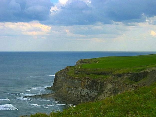


Just a few more cliffs to enjoy before having to deal with the so-called civilization! Most hikers take their pix at the BayHotel sign but decided against that as the Sunday crowd was just too much after over 2weeks of space! Have note even registered in the book yet! Found this other sign across from the BayHotel which is more to my taste. 192m/309km officially, without taking considerations with all the side-trackings, detours and wrong directions…


Headed weary&fatigued uphill again away from the crowd (thank goodness!) to find the B&B but first a side-trip to the church. More on RobinHood’sBay/RBH after a good night sleep as will be here for 2nights to rest and hopefully find somewhere to get a massage and time to reflect!


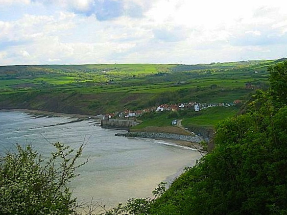
RHB is a small fishing village and a bay located within the NorthYorkMoors NationalPark, 5mi S of Whitby and 15mi N of Scarborough on the coast of NorthYorkshire. Early history about pirates and smuggling seem to be part of it. Took an easy day to explore which is quite delightful on a Mon morning without the crowds. A nice morning walk out to the low-tide beach. Good views from there into land. And of course a pix at the BayHotel is a must and to put my name down in the book there!


Raven House B&B is the second building from the left with this view from the bedroom. Very pleasing to the eyes to spend the last 2 nights of UKc2c hike in this location.


The narrow cobblestones streets are charmingly quaint and the old town huddles around the dock with rows and rows of stone cottages. Have snapped shots from just about every corner…


111 steps of the man-made concrete stairs or the steep road to climb from the sea up to the main road.


Was at the BayHotel for dinner last night and the fresh mackerel is delicious with the salad. This handsome young chap ensured me that they were fresh as he personally caught them that morning. This morning was there and asked if there will be more fresh mackerel and they were honest enough to tell me that it depends if there is a catch. Decided to not bother to walk down and up the hill again.


After learning about jet (origins of the MonkeyPuzzleTree) from Gerry@Maltkiln House, have been keeping an eye on the ground to find it, no such luck. Bought a tiny piece for GBP4 S$7.80 at JetBlackJewellery here. Visited the museum and saw some jet and the half penny token displays.


Got an hour of massage at TreatTherapy GBP40 S$78; feeling relax and tired and with a grey sky, it is perfect for an afternoon nap before packing. Cab will be here tomorrow morning at 0615hrs!


2above pix credits to MartinWilliams, an excellent English photographer and ecologist who lives in HKG.


Nights: Sun-Mon11-12Aug@RavenHouse/RHB. B&B room with bathroom attached. GBP80 S$156 for 2 nights+1breakfast+1load of laundry.
Tue13Aug 2013 – Goodbye to Robin Hood’s Bay


0600hrs the sky was cloudless while waiting for the cab. A final view of RHB, one of the most charming villages soon to be in the memory but not forgotten. Words from this poor writing skills will not be able to describe as these pix on this very perfect high-tide morning with hopes of returning some day. Am told by the cab driver that there are some people in the next village name LAM who are in the boarding school, and no do not know of them nor know of any family members who are in this area! How lucky to be for them but probably at that age, they will not agree and we have all been that age once…
It is good to have an end to journey toward; but it is the journey that matters, in the end – Ernest Hemingway
If you have any questions regarding this hike, plx leave a message here of write to me: amylamsg@hotmail.com